Showing posts with label metric century. Show all posts

Thursday, June 19, 2014

2014 Ride 4 Animal Care

For the second year, TeamFS has sponsored a charity ride to benefit Animal Care, a Greenville County rescue organization that helps find pets new forever homes.  Several friends and I learned last year that this is a very challenging ride, even on the shorter 40 mile route, but a chance to ride up one of my favorite climbs in the upstate gives me reason to come back each year.


The Ride 4 Animal Care has several good climbing sections, but the main feature is a chance to climb Green River Cove.  SteepClimbs.com describes Green River Cove as "[o]ne of the toughest climbs of the area is covered by trees and has 17 tight switchbacks. "   While the climb is much shorter than some of the other local riding attractions, this one is quite well known for those 17 switchbacks.  During the summer months it can be even more challenging because the Green River is a popular tubing and kayaking spot in the upstate as well.
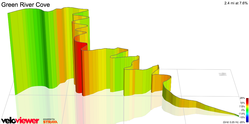

rendering of Green River Cove from VeloViewer.com

Before you can experience Green River Cove, you have to get there.  The ride started at the North Greenville University stadium in Tigerville, SC.  Last year we had an early climb up Callahan Mountain, but because of construction work earlier in the week, the route was changed to bypass that climb and go out Dividng Waters road toward the Greenville Watershed. Most of the riders doing the 40 and 60 mile routes were not upset over this change, as we had plenty of climbing to experience without the extra from Callahan.
At the start time the temperatures were in the mid-60's, although we all knew that this wouldn't last through the day.  As we climbed up the Greenville watershed, the sun was just starting to peek through the treelines, making for some terrific views.


views on the watershed in the morning
Once through Saluda the group I was with worked up to the rest stop where the 40 mile route split from the 60 mile route, and took a break.  One of the big things that I'm still working on with these bigger rides is taking enough of a break to recover before attempting to move on.  Once I get on the bike, I get into a zone where I really don't want to stop.  Getting a rest and recovery is vital, though.  Once I had a banana and some rest time, it was off to head down Holbert's Cove.

Holbert's cove is probably one of the most technical and challenging long stretches of road that I have ridden.  The terrain mixes in hard rollers, with gradients over 15% and hard turns.  It also affords some picturesque views that are sometimes hard to take in an enjoy.


The most technical area of Holbert's Cove is about 3/4 of the way down from Saluda, and is a rather sharp right hand turn.  I've only encountered this turn twice, the first time being during a training ride for the Assault on Mt Mitchell in 2013.  I was already aware of how technical this turn is, and that you have to be careful of your speed as you approach it.  I got myself overly concerned about speed, and didn't get prepared for making the turn, so I overshot it, but was able to correct before heading off into the trees.  I felt very lucky that there were no oncoming cars as I got myself back onto my side of the road as quickly as possible.


Once past Holbert's Cove, you get into the long stretch of mostly flat riding that follows the Green River, knowing that at the end of this stretch is the moster that is known as Green River Cove.  You pass by the river cabins, kayaking locations, and tube rental camps, all set in a rustic setting.  The river looks calm and inviting, and you can see the mountains all around you.  The temperatures in the cove had yet to break 70 degrees, so the wind felt nice.  It leads you into a false sense of security with how serene it is. 


Once you pass over the Green River for the final time, the climbing starts.  With 17 switchbacks, measuring your efforts becomes critical.  The best part for me is that these switchbacks have numbers on each turn, giving me something to focus on during the climb.  Knowing how much of an effort is left allows me to dig deeper to keep going when you really just want to stop and take a long nap.  At the top of the climb is a short ride back to the rest stop in Saluda.  It was a welcome break, and one that I made sure to actually time to make sure I rested well enough before continuing on the route.  With 20 miles left to go, I didn't want to rush through this stop and regret it later in the ride.  After having a banana and refreshing both water bottles, I was on my way.

The last 20 miles of the ride follows the same route as the 40 mile version, going down the Saluda Grade and back up Fork Creek road.  The Saluda Grade is named for the section of road that follows the steepest segment of standard grade railroad line in the United States.  The road has wide sweeping turns, and is a fun section to ride down.  The climb up Fork Creek Road isn't very technical or steep, but with recent road work was a little hazardous in dealing with gravel in the road.  Near the middle of this section there is a fork in the road, and looking at the conditions I chose to take the slightly longer route that had less visible gravel.  I was quite glad that we were traveling up this section, instead of riding down it.  


The final segement of the ride was a trip back down the watershed, and then riding back to Tigerville.  The route takes you past George Hincapie's new resort, Hotel Domistique, finishing up on Chinquapin Road.  It happens that my family was working the rest station that was located in the parking lot of the Hotel, so I made one final stop to fill up water bottles and say hello before riding back in.  

Totally 67 miles and almost 6000' of climbing, the Ride 4 Animal Care is definitely a challenging route, and one that I look forward to riding again next year.  Each year Vince and the TeamFS folks are learning how to improve the event, and I'm sure it will be even more spectacular next year.  Personally I hope that they decide to add event numbers, as they are great souvenirs, if not having an optional medal that can be given to people that complete the full 67mi event.

Wednesday, June 26, 2013

Bee Buzzin' Bike Tour

I was introduced to this ride by someone that I ride with on Sunday afternoons.  What was described to me was a ride that would be relatively flat, and surprisingly fast.  After completing the 62 mile course in just over 3 hours, I have to say that he was accurate on both accounts.  The event is a part of the South Carolina Festival of Flowers, an annual event held in Greenwood, SC.  It travels out in the country around Greenwood, and has a 25 mile and 62 mile (metric century) course.  


The day started out early, and the weather at the house looked questionable.  We ran through a few storms on the way to Greenwood, but as we got to start point the weather looked good.  The downtown was still decorated for the Festival of Flowers, although many of the events ended the day before.  This year the Bike Tour was moved to Sunday, and it felt like it was the final event for the Festival.  I was a little disappointed that the local businesses were closed for the day.  My family had come down to enjoy the festival as well as cheer on the cyclists.  They got to spend time walking around downtown and taking in the topiaries and other sights, though.


An early morning in downtown Greenwood, SC

I knew that Aaron (from SteepClimbs.com) was going to be at this particular ride, as well as a few other folks from the Lexington and Columbia area that I had riden with at other events (including the Assault on the Carolinas and the Assault on Mt Mitchell this year).  We ended up lining up near each other, so I had a chance to ride with them.  This was fortunate, because I prefer to ride with folks I'm familiar with.  It gives me a greater sense of comfort about what is going on around me, and I can get a good idea of the efforts required.

Chatting before the ride start

After going through the instructions, we were given a police and motorcycle lead out.  For this event I had already decided that I would attempt to spend some time in the front group, and I would just see how long I could hang on.  It would be a good test of the last 9 months of training, as I knew the pace would be faster than anything that I was accustomed to.


Heading out

Faster it was!  After we got out of the city, the pace worked itself up to a pretty solid 24-26mph on average, with all the climbing being small grades (1-3%), where the speeds would adjust only slightly.  After a while, the front group, which probably had 50 folks in it total, started to work itself into a rolling pace line.  For those that are not familiar, this is where you work through two lines of cyclists.  In this case the right lane was moving faster, and when you reached the front of the line you'd move over to the left lane and slowly move backwards in the pack.


The goal of this type of pace line is to be able to keep up a higher pace without having the same people up front pulling (and dealing with being the wind break).  I worked my way up to the front a few times, each time trying to work myself further back in the pack to recover more.  One of my big goals for this ride was to make sure I was consuming more on the bike, but at the speeds that I was encountering I wanted to make sure I was paying attention to the road and situations more than eating per se.  Even with that, I was consuming about a bottle an hour of my drink, so I felt I was doing decently with fuel as we went.  I also made a point to have sports beans whenever I could snag them.  I transfer them from the pouches they come in into a tube that is easier to open and close, so snagging a few at a time is relatively easy.  Eating on the bike is going to be a skill that I have to actively work on to improve, so I'm not going to be overly critical of my performances in this regard on a ride by ride basis.


About 26 miles into the ride we came up to a water stop.  Some of the folks I had been riding near in the pack had mentioned that they were planning on stopping to regroup and refuel at this point, leaving the main group.  I decided it was a good place for me to catch my breath, and started to slow down.  Most of the group that planned on stopping missed the stop, so I picked up the pace in an attempt to catch back on, but by then it was just too late.  You can lose the pack in what feels like a blink of an eye, and once you are out of the draft, it's hard to keep the same pace, let alone a hard enough pace to catch back up.
Slowing down for the water stop

The pack is gone!


Once I was dropped, the only thing I could do was just work on catching the next person in front of me.  I caught one cyclist, and we worked together to catch back up with Aaron (who had likewise lost the draft at the stop), and between the 3 of us we were working together for a bit.  Jack, one of the other riders from Lexington SC, had gone back to help pull a few other folks he came to the event with.  After a few minutes we met back up with the lead group, but not in the way that you want to:


This is not how you want to catch the lead group

The danger of rolling pace lines, especially with a group of folks unfamiliar with each other, is that one person not paying attention can be dangerous.  This was the case in the lead group, as two riders ended up having wheel touch (the front wheel of one cyclist met the rear wheel of another).  3 people ended up having their day end at the 31mi mark, but thank God they only had minor injuries.  Road rash is not fun to recover from, but at least they are recovering.


At this point we had about 6 of us working together as we took off from the wreck location.  Without the large pack, our speeds definitely slowed down.  That isn't to say that we meandered our way back to the start/finish line, though.  We worked our way up to the town of Ninety Six, where we reached the final rest stop of the ride.  We took a break here to refill our water bottles and find some shade.  They had bananas cut in half here as well, which was a great snack at this point.


The well stocked refueling station
Finding Shade
Photo op at the rest stop


While we were refueling, one of the other packs of folks rode up, increasing our numbers slightly.  We were all taking turns up front, keeping the pace moving.  The next 15 miles sped by quickly, and we were making the final turn back towards downtown Greenwood.  This is the point where the group broke up some, and it ended up as a sprint to the finish.  We completed the ride in just over 3 hours, in fact my Garmin reported the total ride to be about 3 hours, 9 minutes.  That is an average speed of 20mph during the course, and a moving average of over 21mph.  


Crossing the finish line
While I was disappointed that the Festival didn't have more events for spectators (and cyclists) to do surrounding the event, the ride was very well organized and the route was fantastic.  The course was everything that it was advertised to be, and the rest stops were well stocked and in great locations.  I look forward to doing this event in the future, but I hope they decide to move it back to Saturday, so I can take in the rest of the festival after the ride.